GPS and the End of the Road
On the transformation of travel and discovery
The age-old humbling first task when opening a map for most uses was finding yourself. This was a practical necessity for every map that was not physically anchored in one place and sporting a “You Are Here” sign. No longer in the age of GPS. It’s easy to forget the significance of this change, to think of the blue dot as an eternal finger over your shoulder, not an instant self-centering absent in millennia of previous maps. Today’s circumstantial solipsist is the spot the universe revolves around.
The transformation of maps from physical objects opened on a table to digital representations on navigation consoles, browsers, and smartphones is what William Rankin contemplates in his strikingly impressive book After the Map. The book follows the winding path of the political projects and technological innovations that brought us to the age of GPS. But it is also a sustained theoretical musing on how cartography is more than merely the creation of practical, geographical tools. The making of maps has often been shaped by political aspirations, military aims, and dreams of universal collaboration; and maps in turn shape our understanding of geography and political territory. As Rankin explains:
Writing a history of tools thus makes it possible to avoid some of the blind spots of more familiar forms of legal, political, and economic history, which have a tendency to compartmentalize rather than integrate — separating, for example, technology from politics or concepts from practices…. [T]erritory cannot be understood separate from its tools.
The questions sustaining Rankin’s inquiry — questions that ultimately remain open at the end of the book — are about how the dramatic shift from traditional to GPS mapping might affect not only our sense of the spatial but also our sense of the political.
Consider elementary navigation before GPS. In all but the smallest of scales, Rankin argues, in order to find yourself you would rely on a framework of geopolitical organization that had the practical effect of reinforcing a tight link between geographic and political boundaries. In most cases, that is, you’d be flipping between maps organized by city, state, or country, reminding you constantly of where one territory ends and another begins.
Naturally, maps whose aim is not navigation but the presentation of political information rely on the familiar jigsaw geopolitical schematics of state or county shapes, colored differently depending on whatever the key might require, from literacy rates to income levels to election results. Rankin’s point is that even explicitly navigational maps usually feature levels of political detail that are irrelevant to the purposes of the average traveler — in looking for the town of Rockford, Illinois, it would be almost meaningless to know you’re approaching the Winnebago County line. Rankin does not suggest that this is a federalist conspiracy, but there’s little doubt that it is a vestigial reflection of the historical priorities of mapmaking, which were political before they were navigational.
Political information plays a definitively diminished role in contemporary GPS navigation, and even when present is no longer necessary for locating yourself but rather is anecdotal background, something for your passenger to drone on about. Today, travelers could conceivably take a journey across the United States, or through the Schengen Area (Europe’s open-borders zone, currently comprising twenty-six countries), or across many other territories without being given much, if any, information about where they’re passing through.
A powerful statement on the cumulative effect of traditional mapping on our political understanding of territory is found on the “About” page of Rankin’s excellent blog, Radical Cartography. There, in what seems about as recondite an About page as one can get, is a quotation from the French thinker Jean Baudrillard’s Simulacra and Simulation (1981):
The territory no longer precedes the map…. Henceforth, it is the map that precedes the territory — precession of simulacra — it is the map that engenders the territory.
Baudrillard was tracing a somewhat recent shift in our culture toward an “age of simulation,” in which we have lost what is real because our signs, symbols, and simulations have taken on a life of their own, “substituting signs of the real for the real itself.” Think of the entertainment industry, or The Matrix, the movie that popularized Baudrillard’s phrase “desert of the real.” Thus the portentous expression “precession of simulacra,” which describes how symbols and signs whose original task was to represent real things instead came to be the primary objects of experience by which we know those things.
But even though Baudrillard was thinking about our current times, we can apply his idea also to traditional, political mapmaking: We may think of maps as mere abstractions from real geography, but because traditional maps were created for largely political purposes, they have included political information that most of us know only from maps, not from physical geography — map first, territory second. Even the most well-traveled among us typically first learn state borders from maps, not from direct experience of borders.
The world is understood, unavoidably, within familiar representational frames. This is both an understandable expedient and an arbitrary construct. Rankin’s argument is not so much that this is an insidious arrangement as that these borders have obscured countless other ways to visualize the world. GPS mapping has made possible a host of different types of map previously unavailable, and the aim of After the Map is to examine the tremendous shift in “geo-epistemology” that GPS has enabled. Rankin explains:
The term I use is geo-epistemology; what matters to me is not just what is known about the earth, but how it is known — and how it is used. Geo-epistemology is the difference between knowing your neighborhood through detailed stories, a pictorial guidebook, a map, aerial photographs, the coordinates of a GPS receiver, or simply walking around…. Above all it is about the importance — and the unavoidability — of tools: the goggles of geo-epistemology come in many styles, but they can never be removed. And although for most purposes GPS does indeed offer much more precision than a map, it also constructs a radically different relationship between user, landscape, and authority.
Rankin’s blog offers a trove of maps (many his own work) that seize upon the possibilities furnished by digital mapping to present, for example, population densities in precise clusters of dots instead of the shaded area aggregations of traditional maps. Rankin’s case for innovative mapping is advanced mainly by these stellar images, which trace the reverse of the journey that painting once took from Color Field to Pointillism.
This shift from traditional to GPS mapping is what’s implied by the “after” in the title of Rankin’s book. In the introduction, he describes the traditional image of the map: on a table in a war room, surrounded by figurative ministers and generals. “The power of these maps lies in their ability to act as a stand-in for the original landscape, so that decisions can be made from afar and any new lines drawn with the diplomat’s pen can be scaled up and projected back into the world.” What Rankin depicts is not the obsolescence of the map, per se, but rather its replacement by the coordinate within the map as the foremost tool for comprehending space:
Coordinates shift attention from the area to the point: a stable electronic grid makes it possible to aim missiles, drill for offshore oil, or conduct field research without any overarching awareness of a larger geographic region…. Being glib, one could say that with representation the goal is to know about a place without having to visit. With technologies like GPS, the goal is instead to visit a place without having to know much about it.
The book recounts the creation of several different cartographic systems that rose, and in many cases fell, over the course of the twentieth century. The story involves false starts and dead ends, duplicative systems and squabbles both international and internecine.
Most of the mapping innovations detailed here were designed explicitly for military use. As with countless creations, however, there is a vast difference between original purpose and later applications. Early on, Rankin quotes Michel Foucault: “People know what they do; they frequently know why they do what they do; but what they don’t know is what what they do does.” If war is the father of most maps, his children frequently turn to other occupations at the earliest opportunity.
But the difference between maps for peace and maps for war seriously complicated twentieth-century cartography, which was motivated by two quite different ambitions. On the one hand was cartographic universalism — the hope to perfect a map of the whole globe, requiring the cooperation of the whole globe; on the other was the assignment of precise mathematical coordinates to exact spots on earth — very useful for bombing and artillery.
There are three principal sections to Rankin’s history, addressing first the collaborative effort to build the International Map of the World; second, the rise of cartographic grids; and third, the development of satellite navigation. In combination, the three brought us both the genuinely comprehensive map and the ability to locate precise spots upon it nearly instantly.
The first section also shows how the practical requirements of combat eventually undermined the ambitions of scientific universalism. The International Map of the World (IMW), a collaborative effort to devise exactly what the name suggests, achieved modest progress before the lofty aims of its backers were rerouted into the much more practical requirements of the Second World War.
The IMW project, which eventually involved dozens of countries, was launched by a meeting of just twelve countries in 1909, with representatives from both private and governmental geographic societies. Cartography had long been local and proprietary, and this was an effort to span provincial gaps in pursuit of a world map that would be as uniform and perfect as possible. Though the project was naturally indebted to several powerful actors, mainly in Europe, there was a genuine hope that it would be universally acceptable and not merely an imposition of the preferences and ideologies of larger and more powerful states. Conferences devised basic symbols, graphical conventions, and colors for different landforms. This was the relatively easy part compared to the far more laborious work of each country surveying and producing its own portion of the map.
The efforts of the IMW ground to a halt during the Second World War as the attentions of cartographers were diverted from the general aims of the IMW’s universalism to the specific demands of warfare. It wasn’t that anyone lost interest in cartography — the U.S. military’s main mapping agencies printed 650 million maps during the war — but the kinds of maps produced changed. A map useful to a soldier is entirely different from one useful to a pilot, and the IMW was not nearly as useful as maps narrowly tailored to these ends. Extraneous information in such cases isn’t just unnecessary, it’s actively unhelpful and possibly fatal. “Not only did military mapmakers abandon the idea of the general reader,” Rankin writes, “but accommodating the specialist reader — that is, every reader — was seen as requiring a wide variety of maps that could never share a single source.”
After the war, no less an organization than the United Nations took up responsibility for the IMW. But enthusiasm for the project had cooled irretrievably as specific tools had become more useful. What’s the point of a Swiss Army Knife off of the trail, when you have a regular knife, scissors, corkscrew, and can opener that are each better at their particular tasks?
The focus of Rankin’s second examination is one very particular use of maps: the bombardment grids developed in the First World War. These grids proved pivotal in pioneering a cartography of the point, disregarding all preexisting boundaries and turning “the entire western front into a flat, Euclidean gameboard subject only to the simple rules of plane geometry.” Each coordinate on a grid map represented an exact point on the earth invisible to all but the map’s users — and often, given their firing distances, even to them.
Such grid systems became increasingly common in postwar civilian use as a means to simplify land boundaries and avoid constant surveying. Though eagerly taken up by national governments, grid systems, composed of abstract blocks with no relation to national boundaries, “actively subverted national territoriality at both a symbolic and a straightforwardly practical level.”
Grid maps, however, were frustrated by the curvature of the earth, a round-hole–square-peg disjuncture that’s been a bugbear of cartographers since the demise of the flat-Earth hypothesis. A great variety of grid schemes were devised — competing projections to reflect the earth’s curvature. They all introduced distortions beyond a small coverage area. Second World War efforts to incorporate captured German maps into Allied systems would frequently integrate substantial errors. Consistent surveying, and the recalculation of coordinate grids, were required for every system, making for an “outrageous” amount of work.
The Universal Transverse Mercator (UTM), a series of north–south bands divisible into smaller maps, was the grid map’s leap from the local to the universal, a development spurred by the U.S. Army. Though the project was to make a universal map, it would not involve the cosmopolitan methods of the earlier International Map of the World; rather, the United States simply asked the world for data and then conducted the massive mapping work itself:
The US essentially upstaged the politics of voluntary internationalism and completed what had been conceived of as an enormous, long-term collaborative project in just a few years, all on its own. But the US was also anxious to maintain the legitimacy of the project as an international endeavor, and so other countries were asked to contribute as much as possible and the results were, for the most part, freely shared.
The UTM was a more comprehensive and accurate system than any before, but it still included significant distortions. While the grid was quite accurate for Europe, where wars were thought to be most likely, distortions were severe near the equator — ironically, one of the most substantial was in southern Vietnam. Nonetheless, the system became increasingly common in civilian, commercial, and diplomatic uses, thanks to its superiority to older alternatives. The 1994 peace treaty between Israel and Jordan and the 2006 boundary-setting between Ethiopia and Eritrea each made use of UTM points.
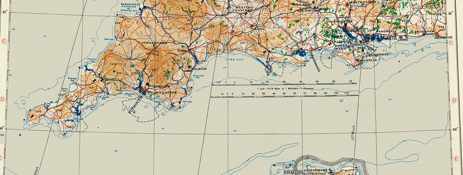
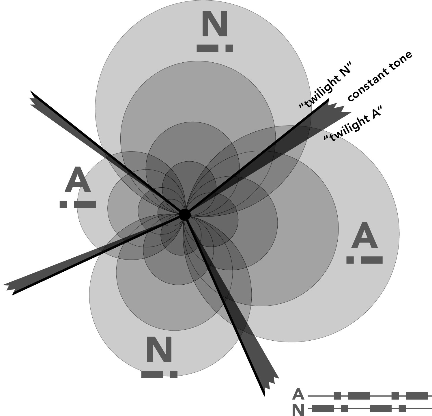 Radio Range’s intersecting beams William Rankin (CC BY-NC-SA) The third section of Rankin’s book follows the path to GPS itself. Radionavigation systems, devised in the 1920s and 1930s for civilian use but finely honed during World War II, made possible the astonishing feat of location-finding that didn’t require a map at all. A fascinating variety of systems sprang up. Most involved using a ground transmitter to transmit Morse code signals. Radio Range, an American system whose heyday was in the 1930s, used a series of transmitter stations that transmitted different Morse signals in different directions. The radio beams would only slightly overlap, creating narrow arcs in which the two staccato Morse patterns merged into a single steady tone. Hearing this tone on the radio would indicate to pilots that they were flying on a known path. Some pilots came to regard these channels “as a railroad track.”
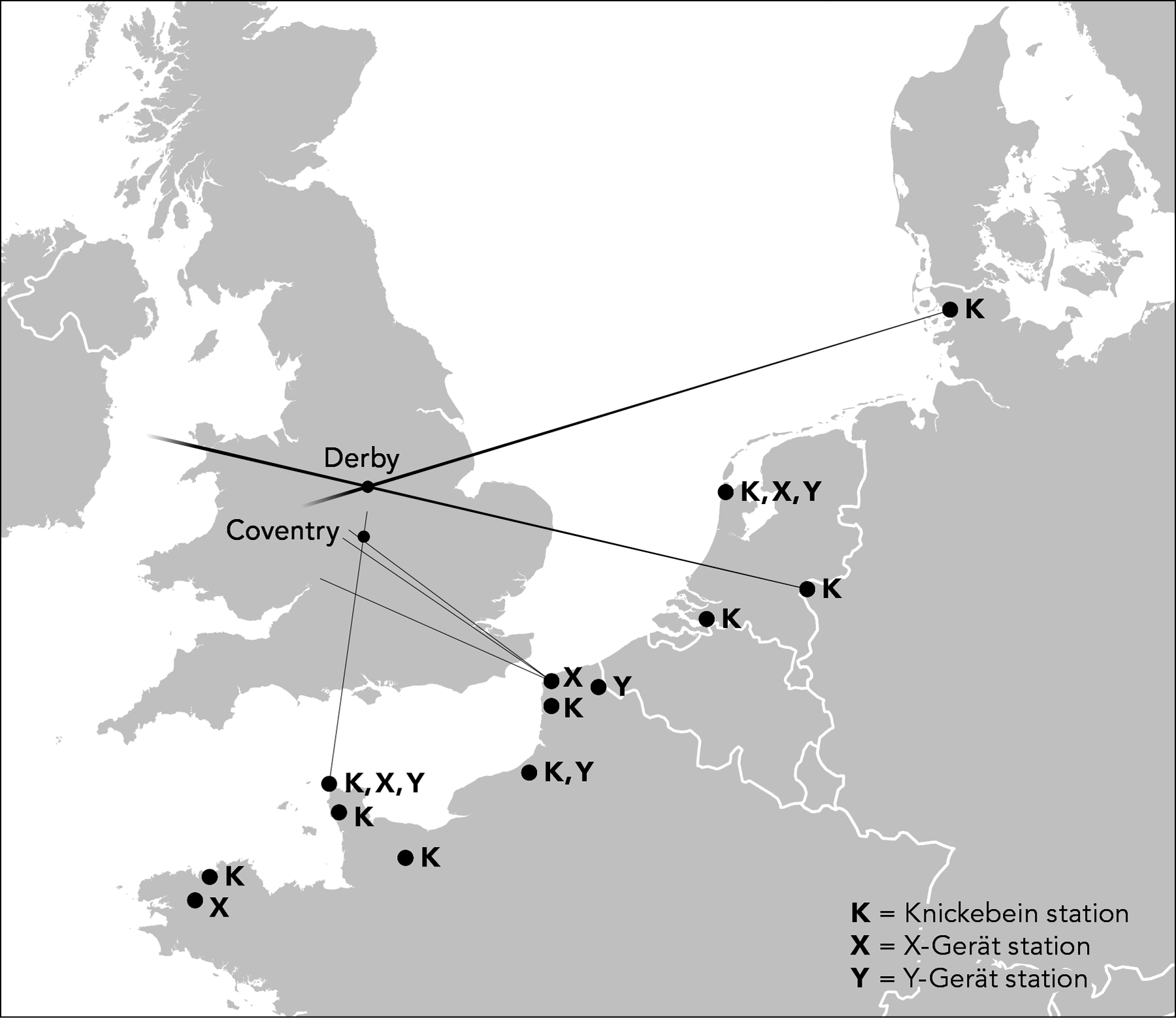
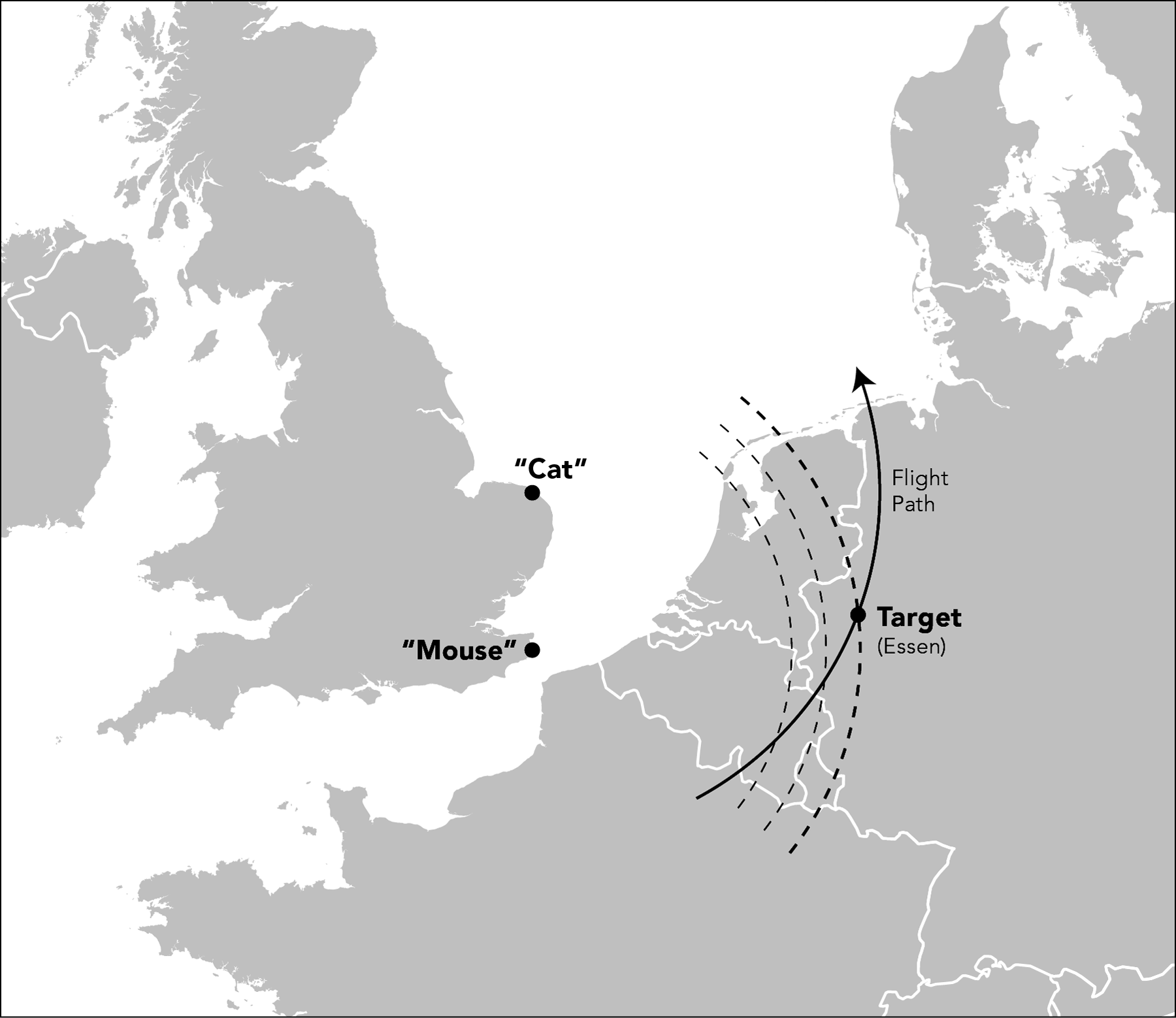 Radionavigation systems used during World War II: German (above) and Allied (below) William Rankin (CC BY-NC-SA) Germans created a similar but more precise system during the war, this one using multiple ground stations sending multiple beams that intersected over a target. Allied systems relied on more complicated equipment that could precisely measure the distance from an airplane to a ground station. To navigate to a target, the plane would monitor its distance from two different ground stations. It would keep a constant distance from one ground station, thus tracing the circumference of a circle, like a protractor; when its distance from the second ground station matched the known distance from the station to the target, it would drop its bombs.
Systems, as ever, were co-opted as soon as they were grasped. Alexander Watson-Watt, a British radar pioneer, jestingly referred to a rapidly repurposed captured German system as a “delightful product of German-British co-operation.” Post-war radionavigation systems saw schoolyard-like levels of competition between and even within national efforts. The United States happily sold navigation equipment to the Eastern Bloc in the 1950s while trying to prevent the British from doing the same.
The two most crucial developments in radionavigation prefiguring GPS were the U.S. Navy’s Omega and Transit systems. Omega, a system of low-frequency radio waves covering huge distances, relied on immense transmitter facilities, while Transit was a pioneering satellite-based system that traced the path of fixed-orbit satellites. Omega could be used almost anywhere in the world at any time, but was accurate only to two kilometers, little better than traditional celestial navigation. Transit was far more accurate, but relied on just four satellites, meaning that location readings were possible only when a satellite was in view, once every 107 minutes. Each system was a choice among tradeoffs, and so each had limited uses.
GPS, developed beginning in the 1970s by the U.S. Department of Defense, was an effort to overcome the duplication and the tradeoffs of existing and proposed radio and satellite navigation systems. GPS satellites transmit a highly precise reading of the time at which a signal was sent; GPS receivers calculate the amount of time a signal took to transmit, and thus infer the distance to the satellite. The tremendous accuracy and universal scope of the GPS system is possible because every point on earth is in view of at least four satellites, permitting an exact three-dimensional location reading anywhere, at any time.
The placement of a GPS receiver in a plane, a ship, or a car was not so difficult to foresee; the real surprise the system’s developers failed to anticipate was the dramatic decrease in the size and cost of receiving devices. The Gulf War provided a particularly striking example of the entanglement of military and civilian uses of GPS. Coalition forces, finding themselves severely short of GPS receivers, ended up relying on commercially available units for 90 percent of their receivers. These proved both instrumental to the coalition’s rapid victory in the conflict and an invaluable infusion of capital to the civilian GPS market, soon helping to push the cost of the receivers down.
When the project was still in development, however, it almost fell prey to late-1970s budget cuts, and its proponents turned increasingly to touting its civilian utility to ensure support from Congress. This effort was not always successful. When the Federal Aviation Administration was invited to a review of early GPS development, its response was, “We don’t want GPS, we don’t need GPS, and if it is ever deployed, we will never use it.” Decades later, the FAA is at last in the midst of implementing NextGen, a massive infrastructure overhaul, scheduled for completion in 2025, that includes making GPS standard for air navigation.
Today, a dedicated GPS receiver sounds about as quaint as a pager or a car phone, and now that we are likely carrying a receiver every time we leave home, it seems no more revolutionary than any of the other objects we are accustomed to dropping multiple times a day. But the mundanity of GPS can be deceiving. Rankin’s conclusion is titled “The Politics in My Pocket” — a reminder that even though GPS is built into our smartphones, the groundbreaking shift it made possible in our conception of the world continues to have political implications.
Though it was a system brought into being to serve U.S. government interests, GPS has caused a radical break in the traditionally close bond between sovereignty and mapping. And yet, for the most part, we don’t really know what this will bring. Borders do not suddenly seem weaker; if anything, as Rankin notes, international boundaries seem more sacrosanct than ever.
In some ways, Rankin’s work is like a history of publishing soon after Gutenberg, or of flight soon after the jet engine. It’s unclear which changes made possible by the new technology will actually occur, but something very notable has changed. We know that GPS has dramatically improved the ability of militaries to project force with precision. Civilians can also zoom in on a roof just about anywhere, and even though they’re not going to fire a missile at it, the possibilities raised are vast.
Rankin’s theoretical musings might occasionally seem far-fetched — his contemplations about how new shifts in geo-epistemology could alter political territoriality seem conjectural at best, for example — but he is reliably careful to acknowledge their speculative nature. In his conclusion he recalls a friend who, while he was writing the book, asked a simple question about the revolution in mapping: “Is this a good thing, or not?” Rankin’s answer at the time was that GPS wasn’t “inherently bad or inherently good — or even inherently neutral.” The aim of the project, he explained then, was “simply to understand the changing politics of geographic knowledge.” That careful, qualified answer he felt compelled to extend as he finished the book: To answer the question, one would have to understand the changes in power relations that GPS enables everywhere. For instance, it seems that geographic knowledge that was once much more closely the purview of the state will be broadly democratized.
One way to view the history of cartography is as the story of what mapmakers choose to withhold from us — always tempered by the reassurance that this is fine and, in fact, inevitable. “Not only is it easy to lie with maps,” Mark Monmonier wrote in a seminal work on the subject, “it’s essential.” The mandate and privilege of every cartographer is choosing just what, and what not, to feature. GPS provides an unprecedented ability for anyone to craft maps, to offer and withhold whatever information one chooses. And so After the Map is “not a story about them — the military, the powerful — transforming the world from on high,” but rather about us using tools that are more powerful, and also more political, than we think they are.
Exhausted by science and tech debates that go nowhere?